

Choosing the right surveying technology can significantly influence project timelines, data quality, site accessibility and overall costs. Different projects require different approaches, whether the objective is to document a long road corridor, map a large development site or capture detailed measurements of an existing building.
Three technologies commonly considered for these requirements are mobile mapping, UAV (unmanned aerial vehicle) surveying and static laser scanning. All three technologies collect spatial data, but each uses a different data acquisition method and is suited to specific environments and levels of detail depending on the project requirements.
Understanding these differences helps engineers, contractors, developers and project managers select an appropriate surveying method based on the actual requirements of their projects.
Table of Contents
ToggleWhat Is the Difference Between Mobile Mapping, UAV Surveying and Static Laser Scanning?
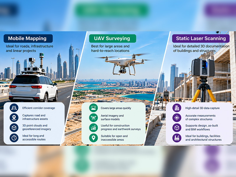
The main difference lies in the data collection approach.- Mobile mapping: Captures geospatial data from a moving platform, commonly a vehicle, making it suitable for linear infrastructure and road corridors.
- UAV surveying: Collects aerial imagery or sensor data using a drone, making it useful for mapping large areas and locations that are difficult to access on foot.
- Static laser scanning: Uses a scanner positioned at fixed locations to capture detailed three-dimensional measurements of buildings, structures and other physical environments.
1. Mobile Mapping: When Is It the Right Choice?
Mobile mapping collects spatial data while a survey platform moves through or along the project area. Depending on the system, equipment may include LiDAR sensors, GNSS positioning, inertial measurement units and panoramic cameras. This approach is particularly useful when a project involves extensive linear infrastructure or numerous assets distributed along a route.Suitable applications
Mobile mapping can be considered for:- Road and highway corridor documentation
- Railway and transportation infrastructure
- Street-level asset inventories
- Urban road networks
- Utility and infrastructure corridor mapping
- Roadside features and infrastructure documentation
Key advantages
Efficient corridor coverage: Data can be captured continuously along accessible routes, reducing the need to set up equipment at every individual point.Rich spatial information: Depending on the equipment, the collected data can include 3D point clouds, georeferenced imagery and spatial information about visible infrastructure.
Reduced fieldwork interruptions: Some road surveys can be completed while traffic continues to move, subject to site conditions, access permissions and safety requirements.
Limitations to consider
Mobile mapping is not automatically the best option for every site. Its performance can depend on GNSS reception, platform movement, traffic conditions, visibility and the availability of suitable routes.Areas behind buildings, inside enclosed structures or outside the scanner’s line of sight may require additional survey methods. Choose this approach when the project primarily involves collecting spatial information along accessible routes rather than capturing every detail of a single structure.
2. UAV Surveying: When Should You Use a Drone?
UAV surveying uses drones equipped with cameras or other sensors to collect data from above. Depending on the sensor and processing workflow, the collected information can support orthomosaic maps, surface models, terrain products and 3D representations. It is particularly useful when aerial coverage is more important than detailed ground-level documentation.Suitable applications
UAV surveying can be considered for:- Large development and construction sites
- Earthwork and stockpile volume assessments
- Aerial mapping of open land
- Construction progress documentation
- Quarries and suitable industrial sites
- Surface inspection of accessible rooftops and structures
Key advantages
Broad-area coverage: A drone can capture imagery across a large site without requiring a surveyor to walk through every section.Useful visual context: Aerial images help project teams understand site layout, surface features, access routes and changes over time.
Repeatable site documentation: When flights are planned consistently and suitable control and processing procedures are used, repeated surveys can help compare project progress.
Limitations to consider
UAV data quality depends on several factors, including flight planning, ground control, sensor capabilities, image overlap, lighting, weather and processing methods. Dense vegetation may prevent aerial imagery from accurately representing the ground beneath it. Vertical surfaces, overhangs and concealed features may also require supplementary measurements.Drone operations must comply with applicable aviation rules, permissions and site-specific safety requirements. Choose UAV surveying when the primary objective is to map a broad surface from above, document progress or obtain aerial context for planning and analysis.
3. Static Laser Scanning: When Is Fixed-Position Scanning Better?
Static laser scanning, also called terrestrial laser scanning, captures three-dimensional measurements from a scanner positioned at fixed locations. Multiple scans can be registered together to create a detailed representation of the surveyed environment. This method is particularly useful when the geometry of buildings, structures or complex facilities must be documented in detail.Suitable applications
Static laser scanning can be considered for:- Building and structural documentation
- Existing-condition and as-built surveys
- Industrial plant and facility documentation
- Architectural features and complex interiors
- MEP coordination and renovation projects
- Detailed 3D records for engineering workflows
Key advantages
Detailed three-dimensional capture: Laser scanners can collect dense point clouds representing visible surfaces and structural features.Useful for complex environments: Multiple scanner positions can capture different sides, levels and interior spaces where suitable access is available.
Supports design and documentation: Processed scan data can be used for measurements, CAD drawings and BIM workflows, depending on the project’s requirements.
Limitations to consider
Static scanning generally requires careful selection of scanner positions and sufficient overlap between scans. Large or obstructed environments may require many setups.Surfaces hidden behind equipment, walls or other objects cannot be captured directly from a scanner position. Additional setups or complementary survey methods may be needed. Choose static laser scanning when detailed documentation of existing structures and their visible geometry is the main priority.
Mobile Mapping vs UAV vs Static Laser Scanning: A Comparison
| Project Consideration | Mobile Mapping | UAV Surveying | Static Laser Scanning |
|---|---|---|---|
| Main data collection approach | Moving platform | Aerial platform | Fixed scanner positions |
| Typical coverage | Linear corridors and accessible routes | Broad areas and surfaces | Buildings and complex structures |
| Primary strength | Efficient corridor data collection | Aerial coverage and site context | Detailed 3D geometry |
| Typical outputs | Point clouds, imagery and spatial datasets | Orthomosaics, surface models and 3D products | Registered point clouds and extracted drawings |
| Ground-level detail | Depends on visibility and sensor setup | Depends on aerial viewpoint and sensor | Detailed capture of visible surfaces |
| Common constraint | Route access and positioning conditions | Weather, permissions and visibility | Occlusions and multiple setup requirements |
| Best selection criterion | Length and continuity of the route | Size and aerial accessibility of the area | Required detail of structures |
How to Choose the Right Surveying Method
Before selecting a technology, assess the project against the following criteria.Define the area to be surveyed
Start by identifying the physical layout of the site. A long road or transportation corridor may favour mobile mapping. A large open development site may be better suited to UAV surveying. A building with complex architectural or structural features may require static laser scanning. For sites combining several environments, a hybrid approach may be more suitable than relying on a single technology.Establish the required accuracy
Accuracy requirements should be defined before selecting equipment. Consider the project’s required positional accuracy, measurement tolerances, coordinate reference system and intended use of the final data. Construction setting-out, structural documentation and preliminary site planning may have very different requirements. Ask the surveying team to explain the achievable accuracy, control procedures, quality checks and limitations for the proposed workflow.Identify visibility and access constraints
Survey technologies capture only what their sensors can observe under the relevant conditions. Buildings, trees, traffic, machinery and other obstructions can affect coverage. UAVs may have limited access because of airspace restrictions or weather, while mobile mapping may be constrained by road access and static scanning may require multiple positions. A site inspection or preliminary survey plan can help identify these issues before fieldwork begins.Consider the final deliverables
The correct technology also depends on what the project team needs to receive. Possible requirements include:- CAD drawings and measured plans
- Registered 3D point clouds
- Orthomosaic maps
- Digital terrain or surface models
- GIS datasets and asset inventories
- BIM-ready data and existing-condition models
- Stockpile or earthwork volume calculations
Compare the total project cost
The lowest initial survey price does not always represent the lowest overall project cost. Consider fieldwork duration, equipment mobilisation, access requirements, processing time, the number of required outputs and the possibility of repeat visits. A technology that captures the necessary information efficiently may offer better overall value, provided it meets the project’s technical requirements.Can Two or More Surveying Technologies Be Used Together?
Yes. Combining technologies can be beneficial when a project includes different types of terrain, infrastructure and structures. For example, a highway development project might use mobile mapping to document roadside infrastructure, UAV surveying to capture surrounding terrain and site-wide surface information, and static laser scanning to record selected bridges or complex structures.Similarly, a building redevelopment project could use aerial data for the surrounding site and terrestrial scanning for detailed interior and structural documentation.
A combined workflow should be planned around a common coordinate reference system, appropriate survey control, compatible deliverables and clearly defined accuracy requirements. This helps ensure that datasets from different sources can be aligned and used together reliably. The objective is not to use every available technology. It is to collect the right information with the most suitable combination of methods.
Questions to Ask Before Commissioning a Survey
Use this checklist when discussing a project with a surveying provider:- What decisions will the survey data support?
- What area, route or structures must be captured?
- What positional accuracy and measurement tolerances are required?
- Are there access restrictions, obstructions or safety considerations?
- Which deliverables and file formats are required?
- Will the data be used for CAD, GIS, BIM, volume calculations or asset management?
- Is one survey method sufficient, or is a combined approach necessary?
- What quality-control procedures will be used?
- What are the expected fieldwork, processing and delivery timelines?
- Are any permits or site approvals required?
Conclusion
Mobile mapping, UAV surveying and static laser scanning serve different purposes. Mobile mapping is suitable for continuous corridor data collection, UAV surveying provides aerial coverage of large areas, and static laser scanning supports detailed three-dimensional documentation of visible structures.The right choice depends on your project’s coverage requirements, accuracy specifications, site conditions, deliverables and budget. For complex projects, combining technologies may provide a more comprehensive solution. Rather than choosing based on equipment alone, it is important to identify your project requirements and select the most suitable surveying approach.
At Accurate Survey Engineering, we provide specialised surveying solutions to support different project needs. Explore our mobile mapping services in UAE for corridor data collection, our UAV drone surveying services for aerial data capture, or our 3D laser scanning services for detailed structural documentation.