A topographical survey might sound technical, but its purpose is simple: to map the natural and man-made features of a piece of land. Whether you’re planning construction, landscaping, or development, this type of survey gives you the detailed information you need to move forward confidently. At Accurate survey, we’ve been helping clients understand their land. Our team of experts specializes in delivering precise surveys tailored to your needs. Let’s break down what a topographical survey is and why it matters.
In this blog, we’ll explore why topographic surveys are so important, when you should consider one, and how topographic survey companies in UAE, like Accurate Survey play a vital role in project success.
Table of Contents
ToggleDo You Really Need a Topographical Survey for Your Project?
If you’re wondering whether a topographical survey is worth the investment, here are some key reasons why it’s essential:- Accurate Planning: A topographical survey provides a clear picture of the land. Architects, engineers, and developers rely on these details to design structures that fit seamlessly into the environment.
- Avoid Costly Mistakes: Without a proper survey, hidden obstacles like underground utilities or uneven terrain could lead to expensive delays. Knowing the land beforehand saves time and money.
- Compliance with Regulations: Many local authorities require a topographical survey before approving permits. This ensures your project meets zoning laws and environmental guidelines.
- Environmental Considerations: Understanding the natural features of a site helps minimize environmental impact. For example, preserving trees or avoiding sensitive areas becomes easier with accurate data.
- Versatility Across Projects: A topographical survey adapts to any scope from small residential developments to large-scale industrial projects. It’s useful for everything from drainage design to flood risk assessments.
What Is a Topographic Survey?
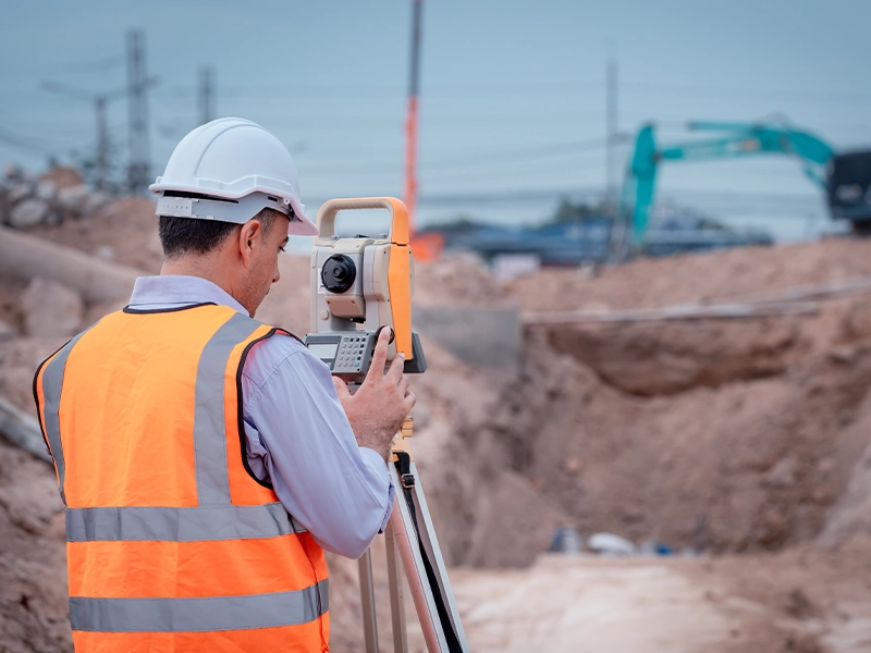
A topographic survey, sometimes referred to as a land survey or contour survey, is a detailed mapping of the surface features of a plot of land. It includes natural features like elevation, trees, and water bodies, as well as man-made structures such as buildings, fences, and roads. These surveys are usually conducted utilising modern technologies such as:- Total Stations
- GPS Equipment
- 3D Laser Scanning
- Drone Photogrammetry
What Are the Objectives of a Topographical Survey?
It is crucial to determine the appropriate level of information and accuracy before commencing any site work. Failing to survey specific assets or features can result in delays to the project and design works. For instance, if trees, level changes, or service covers are not indicated, this could adversely affect the foundation designs, drainage plans, or proposed building heights. Therefore, it is important to conduct a thorough survey to avoid any potential hurdles and ensure a smooth and successful project implementation.When Do You Need a Topographic Survey?
- Before buying or selling land: Know the land’s features before making an investment.
- Before construction: For houses, commercial buildings, or infrastructure.
- For landscaping and site grading: Assists in sculpting the terrain.
- For drainage or flood planning: Understand slopes and elevation levels.
- Road or utility development: Ensures alignment and integration with existing infrastructure
The Role of Modern Equipments in Improving Topographical Surveys
Advances in surveying technology have substantially increased the speed and accuracy of topographic surveys. Dronеs outfitted with high-resolution cameras and LiDAR sensors may collect detailed terrain data from aerial perspectives. GPS and GIS-based mapping systems provide real-time data processing, allowing for more rapid decision-making. As a result, current topographic survey businesses provide more concise, cost-effective, and time-efficient insights than traditional methods. Furthermore, the use of AI-powered analytics in survey data analysis enables more predictive insights, assisting engineers and architects in anticipating potential challenges before they become costly issues. Allowing for more sustainable development approaches increases efficiency and decreases the negative environmental impact. The incorporation of cloud-based platforms also enables seamless data sharing across project stakeholders, ensuring that all decisions are based on real-time, high-accuracy data.-
- GPS Technology: Global positioning systems (GPS) may have been the most significant technological development for land surveying. An assessor can precisely plan limits, framework areas, rise focuses, and other huge spatial information with the assistance of handheld GPS gadgets, which can pinpoint an assessor’s exact geographic directions. GPS makes surveying work significantly faster, as survey crews no longer need to employ traditional sighting and measurement techniques to trace out parcel boundaries and mark critical points. GPS surveying is highly efficient modern technology over any terrain and in remote areas.With real-time kinematic (RTK) GPS, land surveyors can achieve centimeter-level precision in their coordinate data. RTK uses a fixed base station receiver and roving unit to get correction signals that account for atmospheric interference and other factors that create minor inaccuracies.
-
- 3D Laser Scanning: Also known as LIDAR, 3D laser scanning is an emerging tech-based surveying technique that uses millions of laser light pulses to create detailed 3D models and point clouds of infrastructure, topography, boundary features, and more. Specialized LIDAR equipment uses these light pulses to take measurement readings and capture spatial data far denser and more comprehensive than what a surveying crew could gather with traditional methods. This innovation computerizes the information-gathering process, passing it on to the land surveyor to direct the hardware. The gigantic datasets gathered can then be incorporated with different sources like robot symbolism to make exact 3D representations. Engineers, sketchers, improvement groups, and various accomplices can utilize these portrayals.
-
- Drone Aerial Imagery: Thanks to advancements in drone modern technology over the past decade, land surveyors now have access to accurate low-altitude aerial imagery that shows updated views of geography, structures, construction sites, and any land use. Land Surveyors can observe and analyze features that are difficult to inspect from ground level with the assistance of high resolution drone images. This higher point of view gives a priceless visual setting. Drone flights are automated to capture images across a specified area efficiently. Orthorectified imagery that corrects distortions can be used with survey data and 3D models to give highly detailed site representations. These land surveyors furnish clients and public offices with the most recent site infrastructure data.
- Robotic Total Stations: Robotic total stations are advanced measurement instruments that can be self-level, scan entire environments, track prism targets, and collect abundant positional data without a survey crew present. These mechanical gadgets utilize an electronic distance meter, installed programming, and mechanized engines to check designs, territory, and focal points that have intelligent crystals put on them across a 360-degree field of view. This modern technology automates the data-gathering process even more than standard total stations. One surveyor can monitor readings remotely while the total station assembles spatial data autonomously, which recuperates critical fieldwork hours.
The Impact of Modern Technology
Land Surveying Modern technology has given professional land surveyors game-changing field capacities and data handling power, from exact GPS directions to extensive 3D displaying. Surveying work that once required large crews for weeks or months to gather can now be completed by small teams in days thanks to tech-based productivity gains. The definite information and representations now accessible are priceless for framework arranging and advancement across private and public area projects. Pushing ahead, headways like cell phone-based field applications, man-made intelligence handling, and increased reality will just grow the studying prospects.Choose the Right Topographic Survey Company UAE
The success of your project heavily depends on the accuracy and reliability of your survey partner.When choosing a surveying company, consider the following:- Experience & Reputation: Look for established companies like Accurate Survey that have a proven track record across various sectors.
- Technology & Tools: Ensure they use advanced equipment like drones, LiDAR, and 3D scanning.
- Turnaround Time: The timely delivery of survey results is critical to avoiding delays.
- Regulatory Knowledge: Choose a team well-versed with UAE construction and zoning laws.
- Licencing and Certification: All land surveyors must be licensed and certified by the relevant authorities to ensure that they meet professional standards and adhere to legal requirements. The lack of proper certification can lead to inaccurate results and potential legal issues.
- Cost and Transparency: Cost is always a consideration when hiring a service, but it’s important not to base your decision solely on price. The cheapest option may not always provide the best results, while the most expensive company might not offer the best value for your needs.
- Customer Service and Communication: Land surveying can be a complex process, and you will likely need to communicate with the company frequently throughout the project. A company that offers excellent customer service will make the process smoother, more efficient, and less stressful for you.
Why Choose Accurate Survey?
When precision is required, Accurate Survеy is the name that professionals trust. As a leading provider of surveying, mapping, and geospatial solutions, we use cutting-edge technology and expertise to deliver extremely accurate topographic survey services for infrastructure, construction, and urban planning projects. Accurate Survey, one of the leading topographic survey companies in UAE, offering:- Advanced technology: We use cutting-edge GPS and drone-based surveying techniques.
- Experienced Professionals: We use a team of highly qualified topographic surveyors with vast industry experience.
- Unmatched Accuracy: Our surveys provide pinpoint-level precision, reducing project uncertainties.
- Proven Track Record: We have years of experience in Dubai and have successfully delivered topographical data for large-scale infrastructure, commercial, and residential projects.
- Compliance and reliability: We ensure that all surveys comply with regulatory requirements and produce legally admissible reports.
- Comprehensive Services: From preliminary land assessments to sophisticated topographical site surveys, we offer end-to-end solutions tailored to varying industrial requirements.