

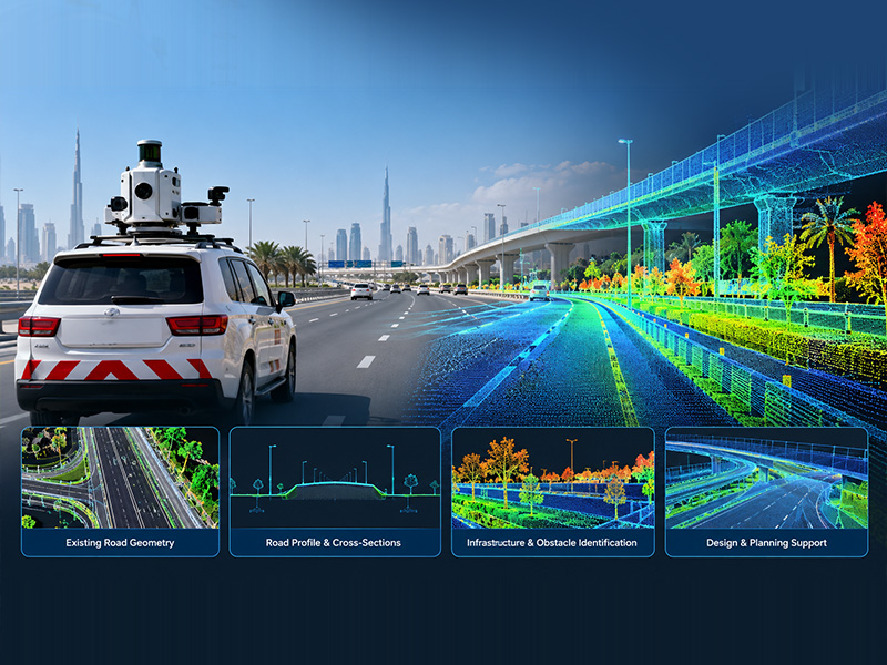
Road widening and highway improvement projects require a clear understanding of existing road conditions before engineering design begins. From pavement edges and road levels to medians, kerbs, barriers and nearby infrastructure, every relevant site feature can influence the proposed design.
Mobile LiDAR surveying helps engineering teams capture detailed three-dimensional information about existing road corridors. By collecting spatial measurements while moving along a road network, this technology provides valuable data for assessing current conditions and planning infrastructure improvements.
For road developers, infrastructure consultants and highway design engineers, reliable survey data can support better design decisions, reduce information gaps and improve coordination during project planning. Accurate Survey Engineering offers mobile mapping services in the UAE to support road corridor surveys and infrastructure projects.
Table of Contents
ToggleWhy Existing-Condition Survey Data Matters in Road Widening
Road widening involves more than adding extra lanes. Depending on the project, engineers may need to modify road geometry, adjust junctions, relocate roadside infrastructure, improve drainage or coordinate proposed works with existing utilities and structures.These activities depend on accurate information about the site as it currently exists.< Outdated drawings or incomplete measurements may not reflect changes caused by previous construction, resurfacing, utility works or surrounding development. This can create uncertainty during design and lead to additional site investigations or revisions.
A detailed road survey helps establish the existing conditions against which proposed improvements can be assessed. Mobile LiDAR data can contribute to this process by capturing road surfaces and visible roadside features across the survey corridor.
What Is Mobile LiDAR Surveying?
Mobile LiDAR surveying uses Light Detection and Ranging (LiDAR) technology mounted on a moving platform, commonly a survey vehicle, to collect three-dimensional measurements of the surrounding environment.The system typically combines laser scanning with positioning and orientation sensors. Depending on the equipment and project requirements, cameras and other sensors may also be incorporated to capture additional information about the road corridor.
The collected measurements are processed into a georeferenced point cloud, which represents the surveyed environment as a large collection of spatial points. For road infrastructure projects, this data can help document:
- Road surfaces, edges and visible pavement features
- Kerbs, medians, barriers and roadside structures
- Streetlights, traffic signs and other visible road assets
- Bridge approaches, junctions and selected overhead structures
- Terrain and elevation changes along the surveyed corridor
How Mobile LiDAR Data Supports Road Widening and Highway Design
1. Capturing Existing Road Geometry
Before widening a road, engineers need to understand its current layout, including lane arrangements, road edges, medians and adjoining features.Mobile LiDAR data can help document these elements along the survey route. The resulting point cloud provides a spatial reference for examining existing road geometry and identifying areas where additional measurements or design investigation may be required.
This information is particularly useful when working with long road sections where site conditions may vary considerably from one location to another.
2. Supporting Road Profile and Cross-Section Analysis
Road widening may require changes to carriageway width, pavement levels, shoulder arrangements and the transition between existing and proposed road sections. Survey data can be processed to extract longitudinal profiles, cross-sections and relevant elevation information, subject to the required survey specifications and data quality.These outputs help design engineers assess existing levels and compare them with proposed road configurations. They can also support the evaluation of differences in elevation across the carriageway and adjacent terrain.
For projects involving extensive road networks, consistent survey coverage helps engineers examine changes in road conditions along the corridor.
3. Identifying Constraints Along the Road Corridor
Existing roadside features can influence how and where a road can be widened. Barriers, lighting columns, signs, retaining structures, bridge approaches and nearby built-up areas may constrain the available space.A detailed three-dimensional representation of visible features helps project teams understand these physical constraints during preliminary design. Engineers can use the survey information to review potential conflicts, identify locations requiring further investigation and coordinate proposed changes with the existing infrastructure.
However, underground pipes and cables cannot be reliably identified from ordinary surface LiDAR data alone. Where underground services may affect the proposed works, a separate utility survey or appropriate detection method is required.
4. Supporting Drainage and Roadside Level Assessment
Drainage considerations are important when widening an existing highway. Changes to pavement levels, road edges and adjacent ground can affect how surface water moves through the corridor.Mobile LiDAR-derived elevation data can support the assessment of visible surface features, road cross-falls and surrounding terrain where the survey specification and data quality are suitable.
This information provides a useful reference for drainage planning and coordination with proposed road levels. Detailed drainage design may still require supplementary topographic surveys, targeted measurements, hydraulic analysis or investigations of existing drainage assets.
5. Improving Coordination Around Junctions and Structures
Highway improvement projects frequently involve junction modifications, access changes, bridge approaches and transitions between different road sections. These locations can be more complex to survey and design because several infrastructure elements meet within a relatively small area.Mobile LiDAR data helps document the surrounding geometry and visible features, allowing engineers to review the existing arrangement before developing proposed changes. Where areas are obstructed or require higher levels of detail, supplementary terrestrial scanning or conventional survey measurements may be necessary.
6. Creating a Reliable Reference for Design and Documentation
Once the collected data has been processed and checked, it can be used to generate suitable engineering outputs based on the project scope.Depending on the requirements, deliverables may include georeferenced point clouds, extracted CAD drawings, road profiles, cross-sections and other existing-condition documentation. These outputs give designers and other project stakeholders a consistent reference for reviewing the surveyed corridor.
The final deliverables should be agreed at the start of the project, including the coordinate reference system, required accuracy, drawing formats, coverage limits and any specific features that need to be extracted.
Mobile LiDAR Surveying vs Conventional Road Surveying
Mobile LiDAR and conventional surveying methods serve complementary purposes. The most suitable approach depends on the project area, required accuracy, site conditions and intended engineering outputs.| Consideration | Mobile LiDAR Surveying | Conventional Surveying |
|---|---|---|
| Data collection | Captures numerous spatial measurements along a route | Measures selected points and features using instruments such as total stations and GNSS equipment |
| Coverage | Useful for documenting extensive road corridors | Useful for targeted measurements and detailed site investigations |
| Existing features | Creates a dense three-dimensional representation of visible surroundings | Provides precise measurements of selected features and control points |
| Data extraction | Supports later extraction of suitable features from processed data | Often focuses on the points and features measured during fieldwork |
| Best application | Detailed corridor documentation and existing-condition assessment | Survey control, critical measurements and targeted verification |
Key Considerations Before Starting a Mobile LiDAR Road Survey
The quality and usefulness of the final data depend on more than the scanning equipment alone. Before starting a survey, project teams should establish the following requirements.Survey coverage: Define the road sections, junctions, shoulders and roadside areas that must be captured.
Required accuracy: Specify the positional and elevation tolerances needed for the intended design work. Confirm that the proposed survey method can meet them.
Survey control and positioning: Establish suitable control and positioning procedures to maintain consistent georeferencing throughout the corridor.
Traffic and site access: Plan data collection around road access, traffic conditions, safety requirements and any necessary permissions.
Feature extraction: Identify which elements need to be mapped, such as pavement edges, kerbs, barriers, signs and selected structures.
Deliverables and formats: Confirm whether the design team requires point clouds, CAD drawings, cross-sections, profiles or other outputs.
Supplementary investigations: Identify areas requiring conventional surveying, underground utility detection, detailed scanning or additional measurements. Addressing these requirements early helps ensure that the collected data is appropriate for its intended engineering application.
Supporting Better Highway Design with Accurate Survey Data
Road widening and highway improvement projects depend on reliable information about existing infrastructure. Mobile LiDAR surveying provides a practical way to document extensive road corridors and capture detailed spatial information that supports engineering assessment and design coordination.From road geometry and elevation analysis to the assessment of visible roadside constraints, processed LiDAR data can help project teams make informed decisions before construction begins. The technology is most effective when supported by suitable survey control, quality checks and additional investigations wherever the project requires them.
Accurate Survey Engineering provides mobile mapping services in the UAE for road corridors, highways and infrastructure projects. Contact our team to discuss your project requirements, survey coverage and the deliverables needed to support your road widening or highway design work.