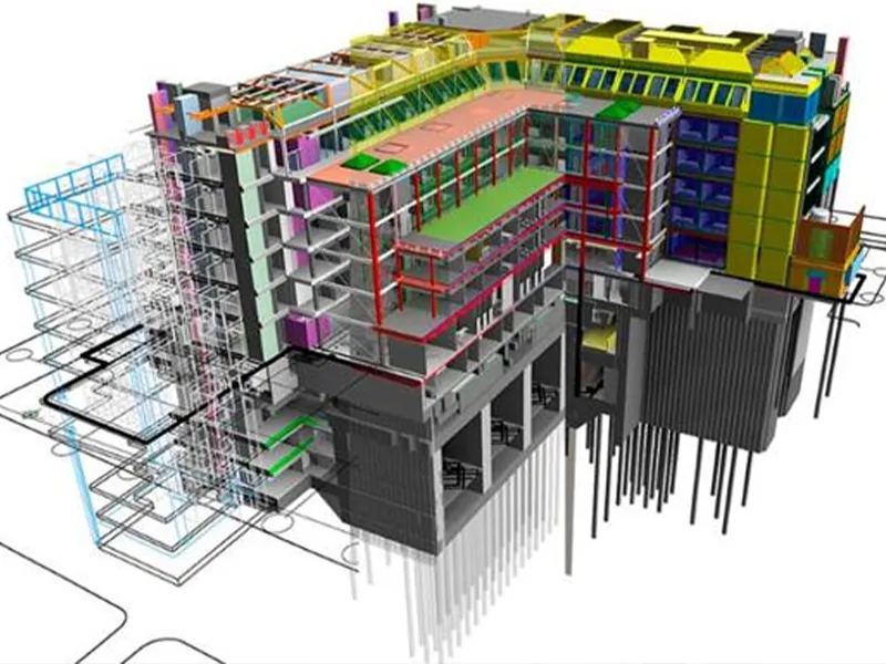
What Is Point Cloud to BIM?
 Point Cloud to BIM is the process of converting 3D laser scan data, known as a point cloud, into a detailed Building Information Model (BIM).
A point cloud consists of millions of measured points collected using 3D laser scanners. These points accurately define the shape, geometry, and dimensions of a building, structure, or asset.
The collected data is then processed and converted into intelligent BIM elements such as:
Point Cloud to BIM is the process of converting 3D laser scan data, known as a point cloud, into a detailed Building Information Model (BIM).
A point cloud consists of millions of measured points collected using 3D laser scanners. These points accurately define the shape, geometry, and dimensions of a building, structure, or asset.
The collected data is then processed and converted into intelligent BIM elements such as:
- Walls
- Floors
- Ceilings
- Doors
- Windows
- Columns
- Structural components
- Mechanical systems
- Electrical systems
- Plumbing systems
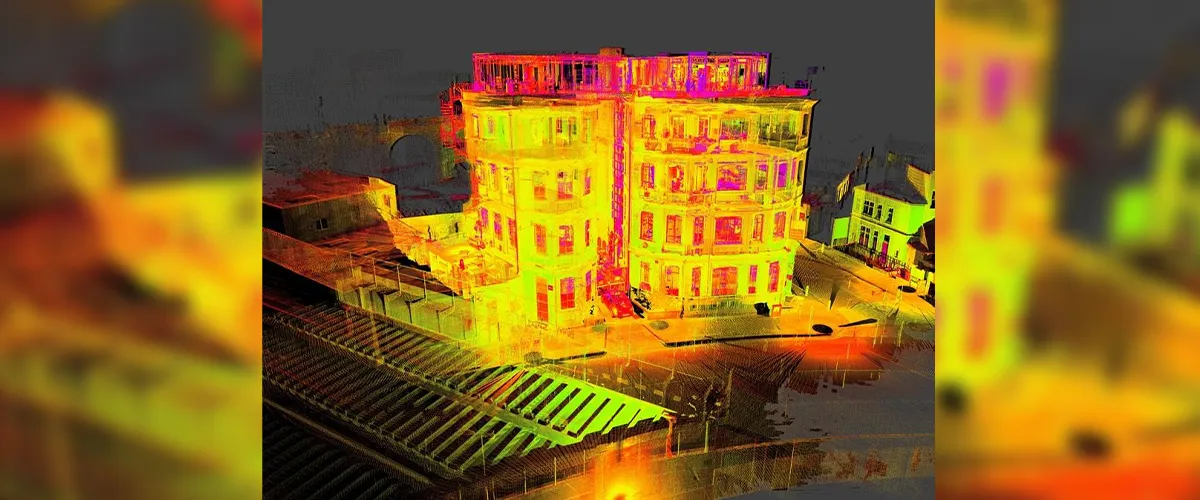
Understanding Point Cloud Data
A point cloud is a digital dataset consisting of millions or even billions of spatial data points captured using laser scanning technology. Each point contains:- X coordinate
- Y coordinate
- Z coordinate
- Location information
- Surface geometry
- Terrestrial Laser Scanning (TLS)
- Mobile Laser Scanning
- Drone-based LiDAR Scanning
- Reality Capture Technologies
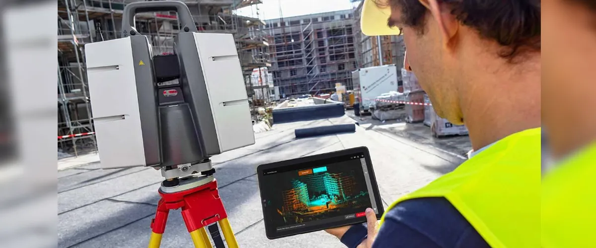
How Does the Point Cloud to BIM Process Work?
The Point Cloud to BIM workflow typically consists of several stages.1. Site Survey and Data Collection
The process begins with a detailed site survey using advanced laser scanning equipment. The scanner captures:- Structural geometry
- Building dimensions
- Architectural features
- Mechanical systems
- Existing site conditions
2. Point Cloud Registration
Multiple scan positions are combined and aligned to create a unified point cloud dataset. This process ensures:- Complete site coverage
- Accurate spatial relationships
- High-quality data representation
3. Point Cloud Processing
Raw scan data is cleaned and optimized. This stage may involve:- Noise removal
- Data filtering
- Alignment verification
- Quality checks
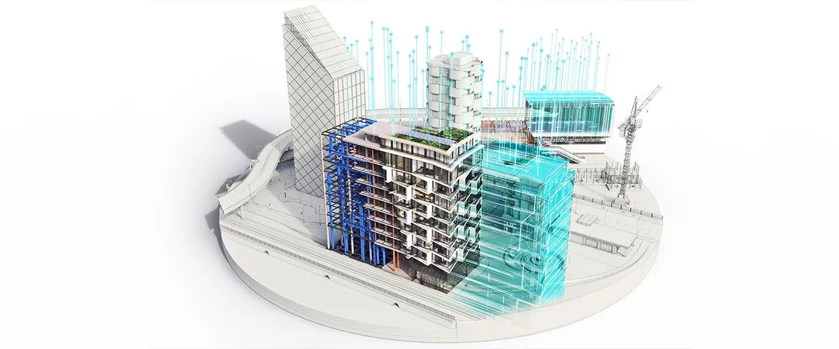
4. BIM Model Creation
The point cloud is converted into an intelligent 3D model using specialized BIM software. The modeling process includes:- Architectural modeling
- Structural modeling
- MEP modeling
- Asset information integration
5. Quality Control and Validation
The final model is verified against the point cloud data to ensure accuracy. This helps ensure that the BIM model accurately represents existing site conditions.Why Is Point Cloud to BIM Important?
Conventional measurement techniques are often time-consuming and vulnerable to human errors. Point Cloud to BIM provides:- Higher accuracy
- Faster data collection
- Better visualization
- Reduced rework
- Improved collaboration
Benefits of Point Cloud to BIM
- Improved Accuracy: Laser scanning captures highly detailed site information with exceptional precision. This reduces measurement errors and improves project outcomes.
- Faster Project Delivery: Site measurements that may take weeks using traditional methods can often be completed in days.
- Better Design Coordination: Precise BIM models facilitate improved coordination among architects, engineers, and contractors.
- Reduced Rework: Reliable existing-condition data helps minimize design conflicts and construction errors.
- Enhanced Facility Management: BIM models provide valuable asset information that can support facility operations and maintenance.
- Improved Renovation Planning: Point Cloud to BIM enables precise documentation of existing structures before renovation or retrofit projects begin.
- Better Decision-Making: Project stakeholders can access accurate digital information throughout the project lifecycle.
Point Cloud to BIM vs Traditional Surveying Methods
| Point Cloud to BIM | Traditional Surveying |
|---|---|
| Captures millions of data points | Limited measurements |
| High level of detail | Lower data density |
| Faster documentation | More time-consuming |
| Creates BIM-ready models | Requires additional modeling |
| Supports digital workflows | Limited digital integration |
| Reduces manual errors | Greater risk of human error |
Applications of Point Cloud to BIM
- Renovation Projects: Accurate existing-condition models help architects and engineers develop renovation plans with confidence.
- Building Retrofits:Point Cloud to BIM supports modernization projects by providing detailed building information.
- Heritage Preservation: Historic buildings can be digitally documented and preserved using BIM technology.
- Facility Management: Asset owners can use BIM models for maintenance planning, space management, and lifecycle management.
- Infrastructure Projects: Roads, bridges, tunnels, airports, and rail systems can benefit from accurate digital documentation.
- Industrial Facilities: Manufacturing plants and industrial sites use Point Cloud to BIM for asset management and operational planning.
Understanding Point Cloud to BIM and Scan to BIM
Point Cloud to BIM is a critical component of the broader Scan to BIM workflow. The process generally follows:- 3D Laser Scanning
- Point Cloud Creation
- Point Cloud Processing
- BIM Modeling
- As-Built Documentation
Point Cloud to BIM in UAE Construction Projects
 The UAE construction sector is increasingly adopting BIM and reality capture technologies to support complex development projects.
Point Cloud to BIM is particularly valuable for:
The UAE construction sector is increasingly adopting BIM and reality capture technologies to support complex development projects.
Point Cloud to BIM is particularly valuable for:
- High-rise buildings
- Commercial developments
- Infrastructure projects
- Industrial facilities
- Heritage conservation
- Smart city initiatives
Why Choose Expert Point Cloud to BIM Services?
Professional service providers offer:- Advanced laser scanning equipment
- Experienced BIM specialists
- Accurate data processing
- Quality assurance procedures
- Industry-standard deliverables
Why Choose Accurate Survey for Point Cloud to BIM Services in UAE?
Successful Point Cloud to BIM projects require more than just advanced laser scanning equipment. They depend on accurate data capture, experienced BIM specialists, and a thorough understanding of existing building conditions to deliver reliable digital models. At Accurate Survey Engineering, we provide comprehensive Point Cloud to BIM and Scan to BIM services for construction, infrastructure, industrial, and renovation projects across the UAE. Our team combines advanced reality capture technologies with BIM expertise to convert complex point cloud data into accurate and information-rich 3D models. Our Point Cloud to BIM capabilities support a wide range of applications, including:- Existing building documentation
- Renovation and retrofit projects
- Architectural BIM modeling
- Structural BIM modeling
- MEP BIM modeling
- As-built BIM documentation
- Facility management and asset management
- Infrastructure and industrial projects
Transforming Existing Structures with Point Cloud to BIM
 Point Cloud to BIM has transformed the way existing buildings and infrastructure are documented, analyzed, and managed. By converting laser-scanned data into intelligent BIM models, organizations can improve project accuracy, streamline workflows, reduce risks, and make more informed decisions.
As the demand for digital construction and asset management solutions continues to grow, Point Cloud to BIM will remain a key technology supporting renovation, facility management, infrastructure development, and modern BIM workflows.
For organizations seeking accurate digital representations of existing structures, Point Cloud to BIM provides a reliable foundation for successful project planning and execution. At Accurate Survey, we deliver professional Point Cloud to BIM services that help architects, engineers, contractors, and facility managers create precise BIM models from laser-scanned data, enabling better project coordination and informed decision-making throughout the asset lifecycle.
Point Cloud to BIM has transformed the way existing buildings and infrastructure are documented, analyzed, and managed. By converting laser-scanned data into intelligent BIM models, organizations can improve project accuracy, streamline workflows, reduce risks, and make more informed decisions.
As the demand for digital construction and asset management solutions continues to grow, Point Cloud to BIM will remain a key technology supporting renovation, facility management, infrastructure development, and modern BIM workflows.
For organizations seeking accurate digital representations of existing structures, Point Cloud to BIM provides a reliable foundation for successful project planning and execution. At Accurate Survey, we deliver professional Point Cloud to BIM services that help architects, engineers, contractors, and facility managers create precise BIM models from laser-scanned data, enabling better project coordination and informed decision-making throughout the asset lifecycle.