
What Is Scan to BIM?
Scan to BIM (Building Information Modeling) is the process of capturing real-world site data using 3D laser scanning and converting it into accurate digital models. Key Features:- High-precision 3D point cloud data
- Creation of detailed BIM models (LOD-based)
- Accurate representation of existing structures and terrain
- Ideal for infrastructure, renovation, and large-scale developments
What Is GIS and Why Does It Matters?
Geographic Information Systems (GIS) manage, analyze, and visualize spatial and geographic data. Key Capabilities:- Mapping large-scale infrastructure networks
- Spatial analysis for planning and decision-making
- Integration of multiple data layers (terrain, utilities, roads)
- Real-time data updates for smart city applications
Why Integrating Scan to BIM with GIS Matters
Individually, both technologies are powerful but together, they create a complete digital ecosystem for infrastructure projects. Key Benefits of Integration:- End-to-End Data Accuracy: Scan to BIM provides precise site data, while GIS ensures it fits into a broader geographic context.
- Improved Decision-Making: Engineers and planners can visualize projects in real-world environments before execution.
- Seamless Collaboration: Teams across design, surveying, and planning can work on a unified data platform.
- Reduced Errors and Rework: Accurate data minimizes design clashes and construction mistakes.
- Faster Approvals: Authorities can validate projects more efficiently with clear, data-backed models.
How does the Integration Work?
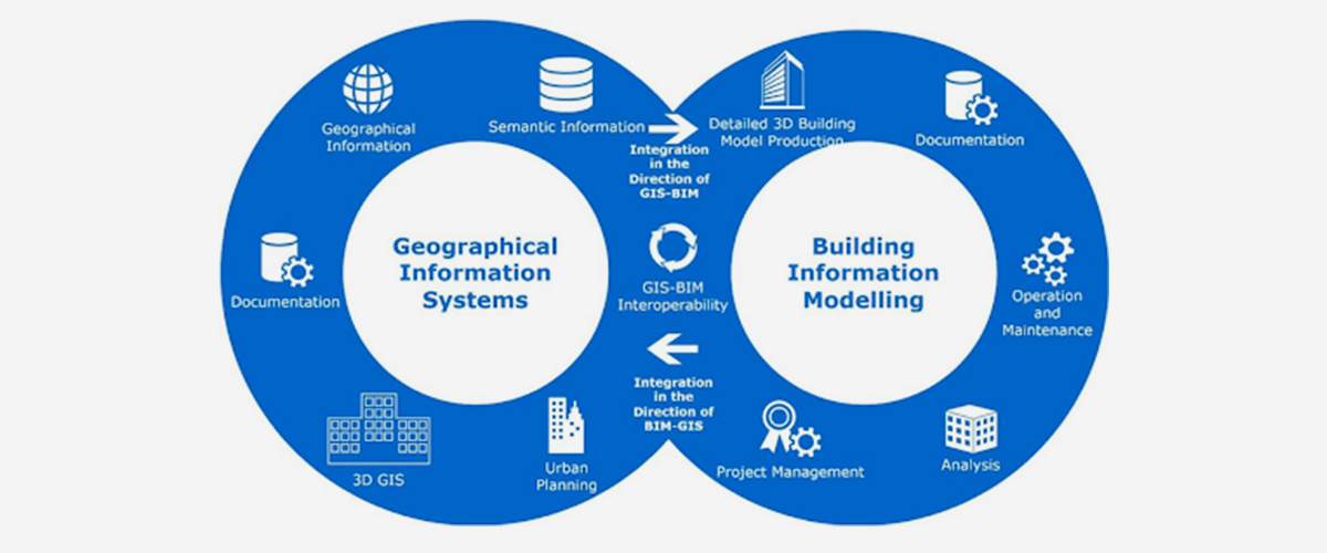 1. Reality Capture Through Laser Scanning
High-resolution 3D laser scanners capture the physical environment, including terrain, structures, and utilities.
2. Point Cloud Data Processing
The scanned data is processed into structured point clouds, forming the base for BIM modeling.
3. BIM Model Creation
Detailed 3D BIM models are developed, representing real-world conditions with high accuracy.
4.GIS Data Integration
The BIM model is integrated into GIS platforms, aligning it with geographic coordinates and mapping systems.
5. Analysis & Visualization
Stakeholders can analyze spatial relationships, detect conflicts, and optimize planning.
6. Implementation & Monitoring
The integrated model supports construction execution and ongoing infrastructure management.
1. Reality Capture Through Laser Scanning
High-resolution 3D laser scanners capture the physical environment, including terrain, structures, and utilities.
2. Point Cloud Data Processing
The scanned data is processed into structured point clouds, forming the base for BIM modeling.
3. BIM Model Creation
Detailed 3D BIM models are developed, representing real-world conditions with high accuracy.
4.GIS Data Integration
The BIM model is integrated into GIS platforms, aligning it with geographic coordinates and mapping systems.
5. Analysis & Visualization
Stakeholders can analyze spatial relationships, detect conflicts, and optimize planning.
6. Implementation & Monitoring
The integrated model supports construction execution and ongoing infrastructure management.
Role of GIS + BIM in Corridor Mapping Projects
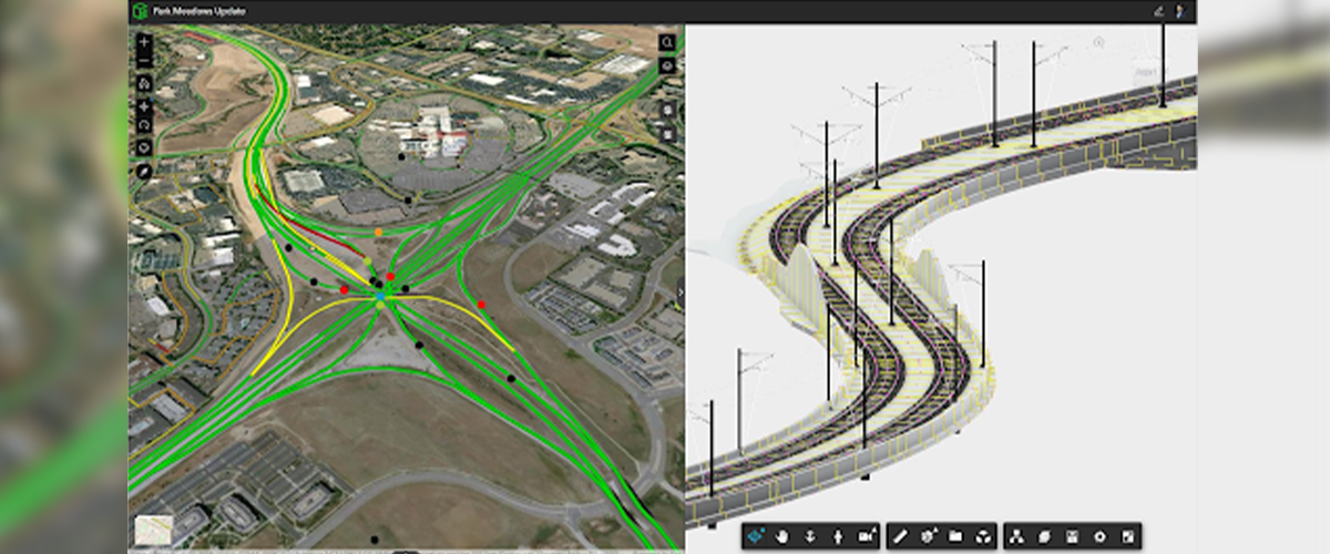 Corridor projects, such as highways, rail lines, pipelines, and utility networks span long distances and pass through diverse terrains, existing infrastructure, and regulatory zones. Managing this complexity requires more than basic surveying; it demands a connected, data-driven approach that combines detailed site reality with large-scale geographic context.
By integrating Scan to BIM with GIS, you gain a powerful workflow that improves accuracy, coordination, and decision-making across the entire corridor.
Corridor projects, such as highways, rail lines, pipelines, and utility networks span long distances and pass through diverse terrains, existing infrastructure, and regulatory zones. Managing this complexity requires more than basic surveying; it demands a connected, data-driven approach that combines detailed site reality with large-scale geographic context.
By integrating Scan to BIM with GIS, you gain a powerful workflow that improves accuracy, coordination, and decision-making across the entire corridor.
How This Integration Adds Value to Your Project?
- Geographically Accurate & Scalable Data: High-precision Scan to BIM data is aligned with GIS coordinates, allowing your project to scale seamlessly across long corridors without losing accuracy.
- Better Alignment & Route Optimization: You can analyze multiple route options by considering elevation, terrain conditions, and existing structures helping you choose the most efficient and cost-effective alignment.
- Improved Clash Detection & Risk Reduction: Identify potential conflicts with existing utilities, roads, or structures early in the planning stage, reducing costly on-site surprises.
- Efficient Land & Boundary Coordination: Integration helps ensure your corridor stays within legal boundaries, avoiding disputes and compliance issues during execution.
- Enhanced Visualization for Stakeholders: With combined BIM and GIS data, you can visualize the entire corridor in real-world context making it easier to communicate plans with clients, consultants, and authorities.
- Faster Approvals & Regulatory Compliance: Clear, data-backed models support smoother approvals from authorities such as Dubai Municipality.
- Ongoing Monitoring & Asset Management: Even after construction, the integrated model can be used for maintenance, upgrades, and future expansion planning.
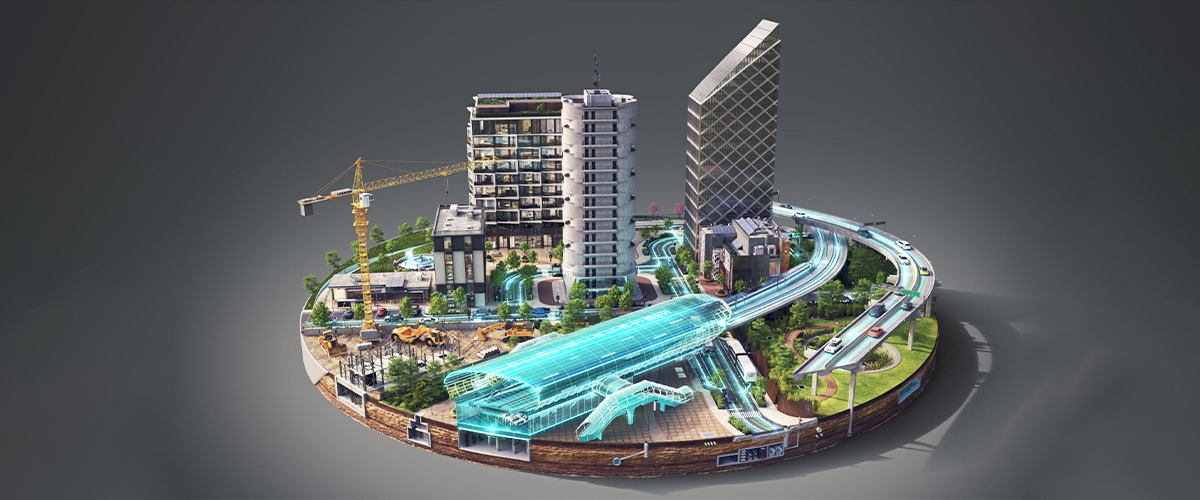
Why Does It Matters for UAE Infrastructure Projects?
In rapidly developing regions like Dubai and Abu Dhabi, corridor projects are becoming more complex due to urban density and large-scale expansion. By using GIS + BIM integration, you can ensure your project is accurate, compliant, and future-ready while minimizing delays, risks, and unnecessary costs.Key Applications of Scan to BIM and GIS Integration in UAE Projects
1. Corridor Mapping (Roads & Highways)
For long-distance infrastructure like highways and road networks, integrating Scan to BIM with GIS enables accurate terrain mapping, boundary alignment, and route planning. This helps you maintain precision across the entire corridor while avoiding costly deviations during execution.2. Rail & Metro Projects
In dense urban environments such as Dubai, this integration ensures precise track alignment, station positioning, and clash detection with existing structures, reducing risks and improving construction efficiency.3. Utility Mapping (Pipelines & Cables)
For underground and above-ground utilities, combining BIM and GIS allows you to identify existing networks, plan new routes, and minimize excavation risks, ensuring safer and more efficient installation.4. Smart City & Digital Infrastructure Development
In modern developments across the UAE, this approach supports digital twin creation, real-time data integration, and long-term asset management, helping you plan smarter and manage infrastructure more effectively.Key Advantages for the UAE Construction Industry
- Enhanced project accuracy
- Reduced project timelines
- Better compliance with authorities
- Improved cost efficiency
- Future-ready digital infrastructure
Common Challenges and How to Overcome Them?
Data Compatibility Issues
- Different platforms and file formats can create integration gaps, leading to delays or data loss.
High Initial Investment
- Advanced technologies like laser scanning and BIM modeling may seem costly at the start.
Lack of Skilled Expertise
- Successful integration requires technical knowledge and experience in both BIM and GIS environments.
Managing Large-Scale Data
- Infrastructure projects generate massive datasets that can be difficult to manage and process efficiently.
Coordination Between Multiple Stakeholders
- Misalignment between surveyors, designers, and planners can impact project timelines.
Why Choose Accurate Survey Engineering?
At Accurate Survey Engineering, we work closely with developers, contractors, and consultants across the UAE to deliver accurate, reliable, and authority-compliant Scan to BIM solutions. When you partner with us, you benefit from:- Accurate site data you can trust for planning and execution
- Seamless integration with GIS platforms for better decision-making
- Faster approvals through compliant and well-structured deliverables
- Reduced project risks and rework with high-precision modeling
Final Thoughts: The Future of Infrastructure Mapping
 The integration of Scan to BIM and GIS is transforming how infrastructure projects are planned and executed in the UAE.
As the country continues to invest in smart cities and large-scale developments, adopting these technologies is no longer optional, it’s essential for staying competitive and compliant.
If your project depends on accurate site data, reliable mapping, and seamless coordination between design and real-world conditions, choosing the right survey partner is critical from day one.
At Accurate Survey Engineering, we help you turn complex site data into clear, actionable insights through advanced Scan to BIM and GIS integration, so you can plan smarter, avoid risks, and move forward with confidence.
Whether you’re working on roads, rail, utilities, or large-scale developments, our team supports you with:
The integration of Scan to BIM and GIS is transforming how infrastructure projects are planned and executed in the UAE.
As the country continues to invest in smart cities and large-scale developments, adopting these technologies is no longer optional, it’s essential for staying competitive and compliant.
If your project depends on accurate site data, reliable mapping, and seamless coordination between design and real-world conditions, choosing the right survey partner is critical from day one.
At Accurate Survey Engineering, we help you turn complex site data into clear, actionable insights through advanced Scan to BIM and GIS integration, so you can plan smarter, avoid risks, and move forward with confidence.
Whether you’re working on roads, rail, utilities, or large-scale developments, our team supports you with:
- High-precision data capture and modeling
- Accurate infrastructure mapping aligned with real-world conditions
- Faster, smoother approval processes
- Reduced errors during design and construction