What is Bathymetry Surveying?
Bathymetry surveying is the measurement of the depth of water bodies and the mapping of underwater topography. It plays a crucial role in:- Port and harbor development
- Offshore oil and gas projects
- Dredging operations
- Subsea cable and pipeline laying
- Coastal zone management
- Environmental impact assessments
Why is Bathymetric Surveying Important in Abu Dhabi?
As a coastal emirate with a dynamic marine economy, Abu Dhabi has seen an increasing need for precise underwater mapping. From Saadiyat Island’s waterfront projects to offshore oil rigs, bathymetric data ensures safety, compliance, and optimized marine construction. Bathymetric surveys also aid in:- Ensuring safe navigation channels
- Monitoring sedimentation and erosion
- Planning artificial islands and coastal developments
- Environmental conservation of marine habitats
What is the Difference Between Bathymetric and Hydrographic Surveys?
While these terms are often used interchangeably, there are key distinctions:| Aspect | Bathymetric Survey | Hydrographic Survey |
|---|---|---|
| Primary Focus | Underwater terrain mapping | Comprehensive water body assessment |
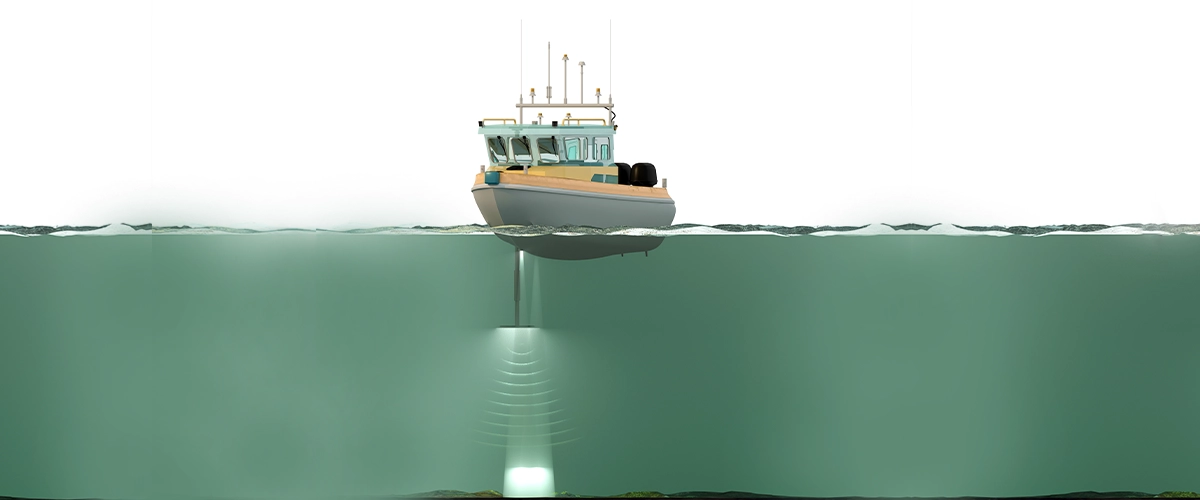
| Tools Used | Single or Multi-beam Echo Sounders, GPS | Echo sounders + tide gauges, current meters, CTDs |
| Output | Seabed topography maps | Nautical charts, navigational aids, sediment analysis |
| Applications | Dredging, marine construction, environmental studies | Navigation, port management, coastal development |
Benefits of Using Bathymetric Drone Services
 Bathymetric drone technology is transforming the way underwater topography is mapped and surveyed, especially in coastal cities like Abu Dhabi where marine infrastructure and environmental conservation are top priorities. Here are the major benefits of using bathymetric drone services:
1. Increased Safety
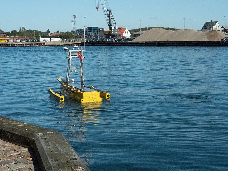
Traditional bathymetric surveys often require manned boats navigating potentially hazardous or shallow waters. Bathymetric drones (either unmanned surface vehicles or aerial drones equipped with sonar) can access these areas safely without endangering human life. This is especially valuable for surveying difficult-to-reach or environmentally sensitive areas.2. Cost-Effective Operations
Using drones for bathymetric surveys significantly reduces the need for large vessels, heavy equipment, and manpower. This leads to lower operational costs while still achieving high-quality and precise results. For companies and government bodies, this means more surveys can be conducted within a limited budget.3. Faster Data Collection
Bathymetric drones can collect and process data much faster than traditional methods. Whether it’s a port, marina, dredging site, or coastal development zone, surveys that would typically take days can now be completed in a matter of hours. This improves project timelines and allows for quicker decision-making.4. High-Resolution and Accurate Data
Equipped with advanced GPS, LiDAR, and multi-beam or single-beam echo sounders, bathymetric drones deliver highly accurate depth and topographic data. These results are crucial for engineering designs, environmental impact assessments, and navigation safety.5. Access to Remote or Shallow Areas
Drones can reach extremely shallow or confined water bodies where traditional boats cannot operate efficiently. This makes them ideal for mapping river mouths, irrigation canals, wetlands, and mangrove areas common geographical features around Abu Dhabi and other UAE coastal zones.6. Environmentally Friendly
Compared to larger survey boats, drones have a smaller carbon footprint and minimal disturbance to marine ecosystems. This is vital for maintaining Abu Dhabi’s sustainable development goals and environmental regulations.7. Real-Time Monitoring and Integration
Many bathymetric drones support real-time data transmission, allowing for instant monitoring and analysis. This is helpful during dredging operations, environmental monitoring, or port maintenance, where real-time insights can prevent delays and errors.8. Scalability for Large or Small Projects
Whether you’re surveying a small lake or an extensive coastline, bathymetric drone services can be easily scaled to match the project size. This flexibility is a key advantage for consultants, developers, and government agencies working on varied marine projects.Why Choose Accurate Survey for Bathymetry Surveying in Abu Dhabi?
Accurate Survey is a trusted name in bathymetric and hydrographic surveying services in the UAE, with extensive experience and a focus on precision and quality.Here’s what sets us apart:
- Cutting-Edge Equipment: We use multi-beam and single-beam echo sounders, side-scan sonar, RTK GPS, and advanced data loggers to gather detailed seabed information.
- Experienced Team: Our hydrographers and marine engineers are highly trained to operate in complex underwater environments, ensuring accurate data acquisition and interpretation.
- Compliance & Safety: We strictly adhere to IHO (International Hydrographic Organization) standards and safety protocols for offshore and nearshore operations.
- Diverse Project Expertise: From oil terminals and offshore platforms to environmental assessments and marine dredging, we serve various sectors across Abu Dhabi and the UAE.
- Comprehensive Reporting: We provide digital charts, 3D models, GIS-compatible datasets, and client-specific bathymetric reports tailored for engineering and planning teams.
- Bathymetry (single-beam/multi-beam)
- Side Scan Sonar Survey
- Sub-bottom Profiling
- Tidal Observation & Correction
- Sound Velocity Profiling
- Underwater Pipeline & Cable Route Survey
- Dredging Volume Calculations