Hydrographic or bathymetric surveying involves mapping and measuring the physical features found beneath water surfaces. It focuses on gathering data about underwater conditions that influence marine activities such as dredging, offshore construction, and drilling. Typically conducted under regulatory authorities, Hydrographic surveying is primarily performed using sensors, sounding techniques, or electronic systems, especially in shallow waters. The data collected is essential for creating nautical charts, which include details such as:
- Available depths
- Improved Channels
- Breakwaters
- Piers
- The aids to navigation harbor facility
This survey also takes part in necessary data collection relating to the construction and development of port facilities, such as pier construction. This helps in finding the loss in capacity due to silt and many uncertainties.
As one of the leading bathymetry survey companies in UAE, Accurate Survey utilizes state-of-the-art technology to deliver accurate, high-resolution mapping of underwater terrains.
Table of Contents
ToggleApplications of Hydrographic Surveying
The following are the applications of hydrographic surveying:- Dock and Harbor Engineering
- Irrigation
- River Works
- Land Reclamation
- Water Power
- Flood Control
- Sewage Disposal
Uses of Hydrographic Surveying
Uses of hydrographic surveying are given below:- Depth of the bed can be determined
- Shore lines can be determined
- Navigation Chart Preparation
- Locate sewer fall by measuring direct currents
- Locating mean sea level
- Scouring, silting, and unevenness of the bed can be detected.
- Tide measurement
- River and stream discharge measurement
- Massive structures such as bridges, dams, and harbors are planned and developed.
Preliminary Steps in Hydrographic Surveying
The process begins by identifying specific control points along the shoreline. Depth measurements, known as soundings, are then taken at various locations using stationary boats. These soundings can be conducted either by moving from the boat to the control points or by fixing a reference point on the boat and taking measurements from the control points. Prior to this, several preliminary steps must be completed:- Reconnaissance
- Locate Horizontal Control
- Locate vertical Control
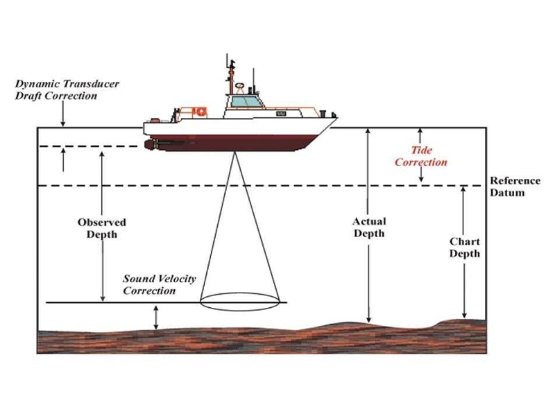
Sounding in Hydrographic Survey
Sounding refers to the process of measuring the depth below the water’s surface. Before conducting sounding, it is essential to establish the mean sea level. When the depth measured (sounding) is subtracted from the mean sea level to find the reduced level of a specific point in a water body, the process closely resembles land levelling. The specific needs for sounding are:- Preparation of navigation charts, which is also an all-time information for future purposes.
- Identifying the material to be dredged in advance is essential to ensure smooth project execution and avoid potential confusion.
- Dredged material should also be utilized in areas where filling is required. Material dumping is also measured.
- Design of backwaters, sea wells requires detailed information that is obtained from sounding.
Single Beam Echo Sounders (SBES)
Single-Beam Echo Sounders (SBES), also referred to as depth sounders or fathometers, measure water depth by calculating the time it takes for a sonar pulse, or “ping”, to travel to the seafloor and back. The pulse is transmitted from a transducer placed just below the water’s surface, and the SBES detects the returning echo. In practice, the sonar signal can also reflect off objects in its path, such as fish, debris, underwater plants, and suspended particles. SBES systems operate using various sonar frequencies. For shallow waters less than 100 meters deep, a frequency of 200 kHz is commonly used. In deeper waters, lower frequencies like 24–33 kHz are preferred due to reduced sound attenuation. To enhance versatility, dual-frequency transducers, such as 33/200 kHz, are often employed. In conditions with high levels of suspended particles, such as during dredging operations, low-frequency sonar proves effective in penetrating the dense resuspended layer to detect the undisturbed seabed below.Multi-Beam Sonar
Multi-Beam Echo Sounders (MBES) utilize sonar technology to emit sound waves toward the seafloor and any submerged objects, then capture and analyze the returning echoes. Mounted beneath a vessel, MBES systems scan wide, fan-shaped sections(“fanned-out”) of the seabed, offering broader coverage compared to traditional surveying methods. While the concepts used are similar to the older methods, multi-beam echo sounder systems are able to collect “swaths” of this data to cover much larger areas than the side-sonar method as well as others. Multi-beam echo sounder systems can also gather data to generate basic, low-resolution images through a process known as acoustic backscatter.USV Echo Sounders
Unmanned Survey Vessels (sometimes also called Unmanned Surface Vessels) provide unique surveying capabilities in numerous bodies of water, including:- Golf Course, Storm Water and Subdivision Ponds
- Streams
- Lakes
- Mining Pits, Tailing Ponds and Quarries
- Dams
- Reservoirs
- Estuaries
- Harbors
- Ports
- Berths
- Channels
- Sewage Treatment Plants
- Coastal Zones
Side Scan Sonar
Bathymetric surveyors also utilize side scan sonar as an additional sonar technique. Side scan sonar systems employ a towfish which, as the name suggests, is a piece of equipment towed behind the ship underwater, in this case carrying sonar equipment. Through a transmission cable connected to a topside processing unit, the side scan sonar emits sound waves that scan the seabed directly beneath the towfish and extend roughly 100 meters to each side. As the vessel moves, the echo data gathered is used to create a broad image of the ocean floor. Compared to multi-beam scanners, side scan sonar is less effective at great depths because it generally measures depth less accurately. However, side scan systems excel at detecting objects and depressions on the seabed, producing clear images. They are frequently used alongside multi-beam scanners to provide more comprehensive survey data.Importance of Bathymetry
Hydrographic and bathymetric surveys serve a wide range of purposes across various submarine-related fields. While some applications are well-established, ongoing advancements in the field continue to discover innovative uses for bathymetric data to benefit the world.Hydrographic Survey in UAE
The Hydrographic Section of the Survey Department within the Municipality oversees all Hydrographic and Oceanographic operations in Dubai’s maritime zones. This includes areas such as Dubai Creek, territorial waters, the EEZ, and international boundaries, ensuring compliance with IHO international standards. Bathymetric surveys of Dubai’s territorial sea and creeks are carried out following International Hydrographic Organization (IHO) Standards Special Order. These include a comprehensive seafloor search using Multi-Beam Echo Sounder Systems with maximum detection capability for high-resolution seabed mapping and inspection, as well as Order 1A for the upper areas.Tide Stations
Dubai Municipality (DM) operates six Tide-Met stations along the Dubai coast and Dubai Creek to monitor water levels and meteorological parameters. Furthermore, DM has installed two offshore buoys to collect meteorological and oceanographic data in offshore areas. The system integrates these six tidal meteorological stations with the two offshore buoys. Besides meteorological parameters, the buoys also measure water quality factors such as water temperature and conductivity.Why Accurate Survey is Your Ideal Partner for Hydrography Surveying?
Accurate Survey is one of the trusted leading hydrographic and bathymetric survey companies in UAE.- Our surveyors utilize a broad array of hydrographic survey sensors, platforms, advanced technology, and software, allowing us to provide a customized data solution tailored to your specific requirements. The survey systems are chosen based on factors such as the scope of work, water depth, operating frequency, distance from shore, accuracy needs, seabed conditions, and vessel size.
- We provide guidance on the most effective approach to achieve your project’s quality, accuracy, timeline, and budget objectives.
- Our skilled team of hydrographic surveyors operates intelligently and efficiently throughout the planning, processing, and reporting stages.
- Whether the project involves an inland river or waterway, a port or harbor, or an offshore location, we possess the expertise and experience to meet the client’s project requirements using our own equipment, vessel fleet, and skilled personnel.
- We can deliver solutions that fulfill clients’ hydrographic needs, covering everything from the land-sea interface to the deepest ocean depths, utilizing acoustic, optical, and remote sensing technologies.
Hydrographic Survey Services We Offer
- Multibeam Hydrographic Survey
- Single-Beam Hydrographic Survey
- 360 Degree Acoustic Imaging
- Side Scan Sonar Imaging
- USV echo sounder survey
Why choose Accurate Survey?
- Specialists in all forms of hydrographic surveying
- A quality assured and totally professional service
- Over 15+ years’ experience in carrying out Bathymetric Surveys
- Comprehensive stock of the latest navigational and echo sounding equipment